
Kangra topographic map
Interactive map
Click on the map to display elevation.
About this map
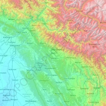
Name: Kangra topographic map, elevation, terrain.
Location: Kangra, Himachal Pradesh, Indien (31.52667 75.61000 32.80667 76.89000)
Average elevation: 1,603 m
Minimum elevation: 228 m
Maximum elevation: 6,113 m
Other topographic maps
Click on a map to view its topography, its elevation and its terrain.
Muhl
Indien > Himachal Pradesh > Ani
Muhl, Ani, Kullu District, Himachal Pradesh, 172026, Indien
Average elevation: 2,251 m
Tso Pema Lake
Indien > Himachal Pradesh > Mandi > Rewalsar
Tso Pema Lake, Rewalsar, Mandi, Mandi District, Himachal Pradesh, 175023, Indien
Average elevation: 1,438 m
Rewalsar
Indien > Himachal Pradesh > Mandi
Rewalsar, Mandi, Mandi District, Himachal Pradesh, 175023, Indien
Average elevation: 1,283 m
Yunam
Indien > Himachal Pradesh > Lahul
Yunam, Lahul, Lahaul und Spiti, Himachal Pradesh, Indien
Average elevation: 5,514 m
Palampur
Palampur, Kangra District, Himachal Pradesh, Indien
Average elevation: 1,525 m
Berli
Indien > Himachal Pradesh > Jubbal > Dhar
Berli, Dhar, Jubbal, Shimla District, Himachal Pradesh, Indien
Average elevation: 2,201 m
Suchen
Indien > Himachal Pradesh > Sainj
Suchen, Sainj, Kullu, Himachal Pradesh, Indien
Average elevation: 2,167 m
Sachen
Indien > Himachal Pradesh > Banjar
Sachen, Banjar, Kullu, Himachal Pradesh, Indien
Average elevation: 2,347 m
Pragpur
Indien > Himachal Pradesh > Dera Gopipur
Pragpur, Dera Gopipur, Kangra, Himachal Pradesh, 177104, Indien
Average elevation: 589 m
Sangla
Indien > Himachal Pradesh > Kinnaur district
Sangla, Kinnaur district, Himachal Pradesh, Indien
Average elevation: 4,250 m
Bangana
Indien > Himachal Pradesh > Bangana
Bangana, Una, Himachal Pradesh, Indien
Average elevation: 588 m
mond
Indien > Himachal Pradesh > Rajgarh
mond, Rajgarh, Sirmaur District, Himachal Pradesh, 173223, Indien
Average elevation: 1,729 m
Meru
Indien > Himachal Pradesh > Saluni > Bhinga
Meru, Bhinga, Saluni, Chamba district, Himachal Pradesh, 176320, Indien
Average elevation: 1,692 m
Chamba
Chamba, Chamba district, Himachal Pradesh, Indien
Average elevation: 2,360 m
Tosa
Indien > Himachal Pradesh > Chamba
Tosa, Chamba, Chamba district, Himachal Pradesh, 176319, Indien
Average elevation: 1,674 m
vyas
Indien > Himachal Pradesh > Rajgarh > vyas
vyas, Rajgarh, Sirmaur, Himachal Pradesh, Indien
Average elevation: 1,103 m
Pariyan
Indien > Himachal Pradesh > Shimla ( Rural ) > Pariyan
Pariyan, Shimla ( Rural ), Shimla, Himachal Pradesh, Indien
Average elevation: 1,580 m
Swarghat
Indien > Himachal Pradesh > Bilaspur > Swarghat
Swarghat, Bilaspur, Himachal Pradesh, 174011, Indien
Average elevation: 983 m
Paonta Sahib
Paonta Sahib, Sirmaur, Himachal Pradesh, Indien
Average elevation: 732 m
Shimla
Indien > Himachal Pradesh > Shimla (urban)
Shimla, Shimla (urban), Shimla, Himachal Pradesh, 171001, Indien
Average elevation: 1,557 m
Lahaul und Spiti
Lahaul und Spiti, Himachal Pradesh, Indien
Average elevation: 4,276 m
Kaza
Indien > Himachal Pradesh > Kaza
Kaza, Lahaul und Spiti, Himachal Pradesh, Indien
Average elevation: 4,161 m
Bharatpur Tent Colony
Indien > Himachal Pradesh > Bharatpur Tent Colony
Bharatpur Tent Colony, Lahaul und Spiti, Himachal Pradesh, Indien
Average elevation: 5,041 m
Berli
Indien > Himachal Pradesh > Berli
Berli, Kangra, Himachal Pradesh, 176219, Indien
Average elevation: 1,794 m
Kullu
Indien > Himachal Pradesh > Kullu
Kullu, Himachal Pradesh, 175100, Indien
Average elevation: 1,808 m