
Chañaral topographic map
Interactive map
Click on the map to display elevation.
About this map
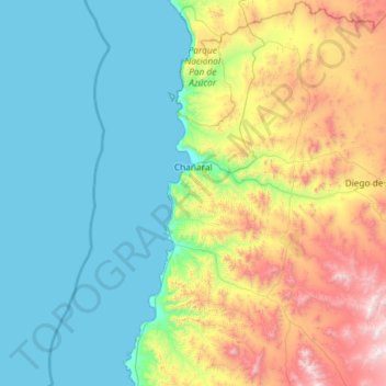
Name: Chañaral topographic map, elevation, terrain.
Average elevation: 471 m
Minimum elevation: 0 m
Maximum elevation: 2,083 m
Die Hafenstadt Chañaral liegt an der Mündung des Río Salado in den Pazifik, in der südlichen Atacama-Wüste, 788 km nördlich von Santiago und 167 km nördlich von Copiapó. Es herrscht hyperarides Klima mit einer durchschnittlichen jährlichen Niederschlagshöhe von 12,3 ± 15,7 mm (ermittelt über 47 Jahre).
Other topographic maps
Click on a map to view its topography, its elevation and its terrain.
El Salado
Chile > Región de Atacama > Provincia de Chañaral > Chañaral > El Salado
El Salado, Chañaral, Provincia de Chañaral, Región de Atacama, Chile
Average elevation: 488 m