
Make a donation
Gear up for your next adventure:
As an Amazon Associate, this site earns from qualifying purchases at no extra cost to you.
Jirapur topographic map
Click on the map to display elevation.
Make a donation
Gear up for your next adventure:
As an Amazon Associate, this site earns from qualifying purchases at no extra cost to you.
Jirapur
Jirapur Tehsil is bounded by Khilchipur Tehsil towards east, Nalkheda Tehsil towards south, Susner Tehsil towards west, Bakani Tehsil towards the north. Sarangpur City, Shajapur City, Pachore City, Jhalawar City are the nearby Cities to Jirapur. This city is near on MP and Rajasthan border. Jirapur consists of 88 Villages and 88 Panchayats. It is 434 metres in elevation.
Make a donation
Gear up for your next adventure:
As an Amazon Associate, this site earns from qualifying purchases at no extra cost to you.
About this map
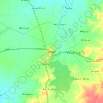
Name: Jirapur topographic map, elevation, terrain.
Average elevation: 396 m
Minimum elevation: 377 m
Maximum elevation: 431 m
Make a donation
Gear up for your next adventure:
As an Amazon Associate, this site earns from qualifying purchases at no extra cost to you.