Geolocate

Walmer topographic map

Click on the map to display elevation.

About this map

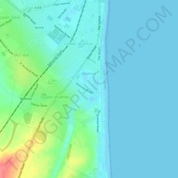
Name: Walmer topographic map, elevation, terrain.

Location: Walmer, Dover, Kent, South East England, England, United Kingdom (51.18882 1.37798 51.21952 1.40609)

Average elevation: 12 m

Minimum elevation: 0 m

Maximum elevation: 66 m

Gear up for your next adventure:

🦟Heavy Duty Insect Repellent - Essential protection against flies, mozzies, and march flies
🏃Compression Recovery Socks - Reduce leg fatigue after heavy days of elevation gain
📚Map Reading & Navigation Guides - Master the art of interpreting topographic contours and symbols
🥾Hiking Gaiters - Leg protection for trails
📱Shockproof Phone Cases - Extra protection for your smartphone against drops on rocky terrain

As an Amazon Associate, this site earns from qualifying purchases at no extra cost to you.