
rio truful-truful topographic map
Interactive map
Click on the map to display elevation.
About this map
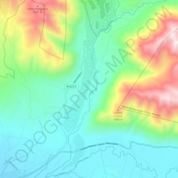
Name: rio truful-truful topographic map, elevation, terrain.
Average elevation: 866 m
Minimum elevation: 469 m
Maximum elevation: 1,867 m
Other topographic maps
Click on a map to view its topography, its elevation and its terrain.
Comunidad Francisco Ovando
Chile > Región de la Araucanía > Provincia de Cautín > Melipeuco > Comunidad Francisco Ovando
Comunidad Francisco Ovando, Melipeuco, Provincia de Cautín, Región de la Araucanía, Chile
Average elevation: 677 m