
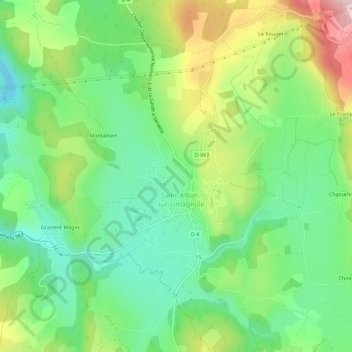
Biffares topographic map
Interactive map
Click on the map to display elevation.
About this map
Name: Biffares topographic map, elevation, terrain.
Average elevation: 983 m
Minimum elevation: 887 m
Maximum elevation: 1,153 m
Other topographic maps
Click on a map to view its topography, its elevation and its terrain.
Lou Toura-Sud
France > Occitanie > Lozère > Saint-Alban-sur-Limagnole > Lou Toura-Sud
Lou Toura-Sud, Saint-Alban-sur-Limagnole, Mende, Lozère, Occitanie, France métropolitaine, 48120, France
Average elevation: 988 m
Les Faux
France > Occitanie > Lozère > Saint-Alban-sur-Limagnole
Les Faux, Saint-Alban-sur-Limagnole, Mende, Lozère, Occitanie, France métropolitaine, 48120, France
Average elevation: 1,141 m
L'Hôpital
France > Occitanie > Lozère > Saint-Alban-sur-Limagnole
L'Hôpital, Saint-Alban-sur-Limagnole, Mende, Lozère, Occitanie, France métropolitaine, 48120, France
Average elevation: 987 m
Limbertès
France > Occitanie > Lozère > Saint-Alban-sur-Limagnole
Limbertès, Saint-Alban-sur-Limagnole, Mende, Lozère, Occitanie, France métropolitaine, 48120, France
Average elevation: 1,124 m