
Thank you for supporting this site ❤️
Make a donation
Make a donation
Gear up for your next adventure:
As an Amazon Associate, this site earns from qualifying purchases at no extra cost to you.
Sagaranten topographic map
Click on the map to display elevation.
Thank you for supporting this site ❤️
Make a donation
Make a donation
Gear up for your next adventure:
As an Amazon Associate, this site earns from qualifying purchases at no extra cost to you.
About this map
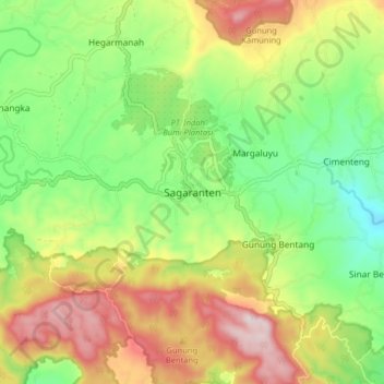
Name: Sagaranten topographic map, elevation, terrain.
Location: Sagaranten, Sukabumi, West Java, Java, 43181, Indonesia (-7.25900 106.84558 -7.17900 106.92558)
Average elevation: 426 m
Minimum elevation: 225 m
Maximum elevation: 700 m
Thank you for supporting this site ❤️
Make a donation
Make a donation
Gear up for your next adventure:
As an Amazon Associate, this site earns from qualifying purchases at no extra cost to you.