Geolocate

Walhalla topographic map

Click on the map to display elevation.

About this map
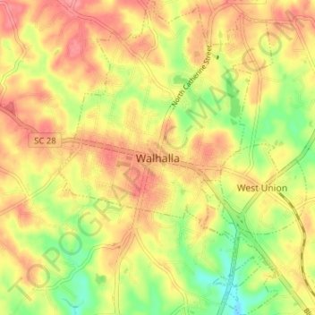
Name: Walhalla topographic map, elevation, terrain.

Location: Walhalla, Oconee County, South Carolina, 29691, United States (34.73879 -83.08411 34.79104 -83.03947)

Average elevation: 296 m

Minimum elevation: 249 m

Maximum elevation: 330 m

Other topographic maps

Click on a map to view its topography, its elevation and its terrain.

Newry

United States > South Carolina > Oconee County

Average elevation: 251 m

Phinney

United States > South Carolina > Oconee County

Average elevation: 270 m

Madison

United States > South Carolina > Oconee County

Average elevation: 240 m

Cheohee

United States > South Carolina > Oconee County

Average elevation: 339 m

Wexford

United States > South Carolina > Oconee County

Average elevation: 232 m

Dalton

United States > South Carolina > Oconee County > Seneca

Average elevation: 267 m

Gear up for your next adventure:

🔋Solar Power Banks - Solar chargers for outdoors
📕Hiking Guide Books - Guides for hiking trails
👕UPF 50+ Sun Shirts - Essential protection against the harsh Australian sun during field work
🧥Thermal Emergency Blankets - Compact Mylar blankets to prevent hypothermia if stranded overnight
⛺Lightweight Tents - Compact tents for backpacking

As an Amazon Associate, this site earns from qualifying purchases at no extra cost to you.