Geolocate

Monknash topographic map

Click on the map to display elevation.

About this map

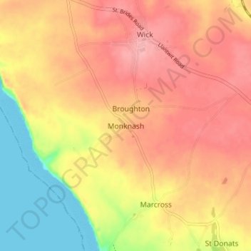
Name: Monknash topographic map, elevation, terrain.

Location: Monknash, Vale of Glamorgan, Wales, CF71 7QQ, United Kingdom (51.40460 -3.57500 51.44460 -3.53500)

Average elevation: 64 m

Minimum elevation: 0 m

Maximum elevation: 104 m

Other topographic maps

Click on a map to view its topography, its elevation and its terrain.

Penarth

United Kingdom > Wales > Vale of Glamorgan

Average elevation: 17 m

Barry

United Kingdom > Wales > Vale of Glamorgan

Average elevation: 29 m

Dinas Powys

United Kingdom > Wales > Vale of Glamorgan

Average elevation: 30 m

St. Athan

United Kingdom > Wales > Vale of Glamorgan > St Athan

Average elevation: 30 m

Romilly Park

United Kingdom > Wales > Vale of Glamorgan > Barry

Average elevation: 26 m

Barry

United Kingdom > Wales > Vale of Glamorgan

Average elevation: 29 m

Barry

United Kingdom > Wales > Vale of Glamorgan

Average elevation: 29 m

Barry

United Kingdom > Wales > Vale of Glamorgan

Average elevation: 29 m

Gear up for your next adventure:

🦘Outback Survival Gear - Essential gear for Australian outback
Ultralight Solo Tents - Compact shelters for multi-day topographic surveying expeditions
🦯Trekking Poles - Walking poles for hiking stability
🗺️Topographic Maps - Detailed maps for hiking and navigation
🛌Compact Down Sleeping Bags - Warmth without the bulk, ideal for backcountry camping

As an Amazon Associate, this site earns from qualifying purchases at no extra cost to you.