
Thank you for supporting this site ❤️
Make a donation
Make a donation
Gear up for your next adventure:
As an Amazon Associate, this site earns from qualifying purchases at no extra cost to you.
Karbastı topographic map
Click on the map to display elevation.
Thank you for supporting this site ❤️
Make a donation
Make a donation
Gear up for your next adventure:
As an Amazon Associate, this site earns from qualifying purchases at no extra cost to you.
About this map
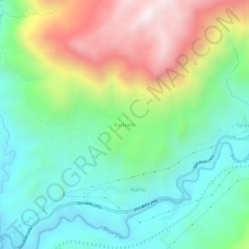
Name: Karbastı topographic map, elevation, terrain.
Location: Karbastı, Bitlis, Eastern Anatolia Region, Turkey (38.20699 41.83501 38.24699 41.87501)
Average elevation: 1,174 m
Minimum elevation: 763 m
Maximum elevation: 1,965 m
Thank you for supporting this site ❤️
Make a donation
Make a donation
Gear up for your next adventure:
As an Amazon Associate, this site earns from qualifying purchases at no extra cost to you.