
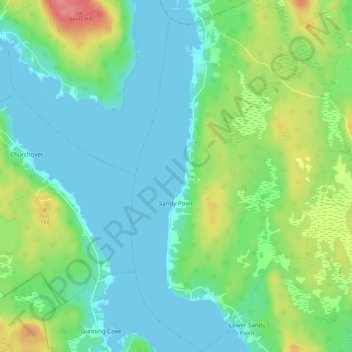
Sandy Point topographic map
Interactive map
Click on the map to display elevation.
About this map
Name: Sandy Point topographic map, elevation, terrain.
Average elevation: 23 m
Minimum elevation: -1 m
Maximum elevation: 84 m
Other topographic maps
Click on a map to view its topography, its elevation and its terrain.
Barrington Passage
Canada > Nova Scotia > Shelburne County > Barrington Passage
Barrington Passage, Municipality of the District of Barrington, Shelburne County, Nova Scotia, B0W 1E0, Canada
Average elevation: 13 m
Rocky Creek
Canada > Nova Scotia > Shelburne County > Lower Clyde River
Rocky Creek, Lower Clyde River, Municipality of the District of Barrington, Shelburne County, Nova Scotia, B0W 1R0, Canada
Average elevation: 48 m
West Head
Canada > Nova Scotia > Shelburne County
West Head, Municipality of the District of Barrington, Shelburne County, Nova Scotia, B0W 3B0, Canada
Average elevation: 3 m
Blacksmiths Beach
Canada > Nova Scotia > Shelburne County > Cape Negro Island
Blacksmiths Beach, Cape Negro Island, Municipality of the District of Barrington, Shelburne County, Nova Scotia, B0W 1K0, Canada
Average elevation: 2 m