
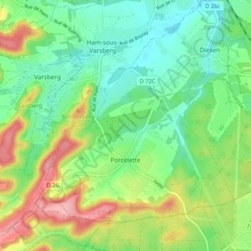
Porcelette topographic map
Interactive map
Click on the map to display elevation.
About this map
Name: Porcelette topographic map, elevation, terrain.
Average elevation: 257 m
Minimum elevation: 210 m
Maximum elevation: 343 m
Other topographic maps
Click on a map to view its topography, its elevation and its terrain.
Saint-Jean-Rohrbach
Saint-Jean-Rohrbach, Sarreguemines, Moselle, Grand Est, France métropolitaine, 57510, France
Average elevation: 238 m
Thionville
Thionville, Moselle, Grand Est, France métropolitaine, 57100, France
Average elevation: 190 m
Metzeresche
Metzeresche, Thionville, Moselle, Grand Est, France métropolitaine, 57920, France
Average elevation: 227 m
Rochonvillers
Rochonvillers, Thionville, Moselle, Grand Est, France métropolitaine, 57840, France
Average elevation: 373 m
Communauté d'agglomération du Val de Fensch
Communauté d'agglomération du Val de Fensch, Moselle, Grand Est, France métropolitaine, France
Average elevation: 261 m
Hauconcourt
Hauconcourt, Metz, Moselle, Grand Est, France métropolitaine, 57280, France
Average elevation: 167 m
Sarreinsming
Sarreinsming, Sarreguemines, Moselle, Grand Est, France métropolitaine, 57905, France
Average elevation: 246 m
Saint-Quirin
Saint-Quirin, Sarrebourg-Château-Salins, Moselle, Grand Est, France métropolitaine, 57560, France
Average elevation: 432 m
Châtel-Saint-Germain
Châtel-Saint-Germain, Metz, Moselle, Grand Est, France métropolitaine, 57160, France
Average elevation: 293 m
Saint-Hubert
Saint-Hubert, Metz, Moselle, Grand Est, France métropolitaine, 57640, France
Average elevation: 261 m
Norroy-le-Veneur
Norroy-le-Veneur, Metz, Moselle, Grand Est, France métropolitaine, 57140, France
Average elevation: 268 m
Gros-Réderching
Gros-Réderching, Sarreguemines, Moselle, Grand Est, France métropolitaine, 57410, France
Average elevation: 328 m
Kédange-sur-Canner
Kédange-sur-Canner, Thionville, Moselle, Grand Est, France métropolitaine, 57920, France
Average elevation: 226 m
Roupeldange
Roupeldange, Forbach-Boulay-Moselle, Moselle, Grand Est, France métropolitaine, 57220, France
Average elevation: 211 m
Woustviller
Woustviller, Sarreguemines, Moselle, Grand Est, France métropolitaine, 57915, France
Average elevation: 237 m
Ancerville
Ancerville, Metz, Moselle, Grand Est, France métropolitaine, 57580, France
Average elevation: 237 m
Saint-Avold
Saint-Avold, Forbach-Boulay-Moselle, Moselle, Grand Est, France métropolitaine, 57500, France
Average elevation: 271 m
Guessling-Hémering
Guessling-Hémering, Forbach-Boulay-Moselle, Moselle, Grand Est, France métropolitaine, 57380, France
Average elevation: 265 m
Grundviller
Grundviller, Sarreguemines, Moselle, Grand Est, France métropolitaine, 57510, France
Average elevation: 247 m
Fresnes-en-Saulnois
Fresnes-en-Saulnois, Sarrebourg-Château-Salins, Moselle, Grand Est, France métropolitaine, 57170, France
Average elevation: 288 m
Ormersviller
Ormersviller, Sarreguemines, Moselle, Grand Est, France métropolitaine, 57720, France
Average elevation: 309 m
Henriville
Henriville, Forbach-Boulay-Moselle, Moselle, Grand Est, France métropolitaine, 57450, France
Average elevation: 281 m
Le Val-de-Guéblange
Le Val-de-Guéblange, Sarreguemines, Moselle, Grand Est, France métropolitaine, 57430, France
Average elevation: 229 m
Mainvillers
Mainvillers, Forbach-Boulay-Moselle, Moselle, Grand Est, France métropolitaine, 57380, France
Average elevation: 270 m
Vahl-lès-Bénestroff
Vahl-lès-Bénestroff, Sarrebourg-Château-Salins, Moselle, Grand Est, France métropolitaine, 57670, France
Average elevation: 246 m
Seingbouse
Seingbouse, Forbach-Boulay-Moselle, Moselle, Grand Est, France métropolitaine, 57455, France
Average elevation: 293 m
57280
France > Grand Est > Moselle > Hauconcourt
57280, Hauconcourt, Metz, Moselle, Grand Est, France métropolitaine, France
Average elevation: 164 m
Givrycourt
Givrycourt, Sarrebourg-Château-Salins, Moselle, Grand Est, France métropolitaine, 57670, France
Average elevation: 231 m
Mondelange
Mondelange, Thionville, Moselle, Grand Est, France métropolitaine, 57300, France
Average elevation: 162 m
Loutzviller
Loutzviller, Sarreguemines, Moselle, Grand Est, France métropolitaine, 57720, France
Average elevation: 308 m