
Make a donation
Gear up for your next adventure:
As an Amazon Associate, this site earns from qualifying purchases at no extra cost to you.
Covert Township topographic map
Click on the map to display elevation.
Make a donation
Gear up for your next adventure:
As an Amazon Associate, this site earns from qualifying purchases at no extra cost to you.
About this map
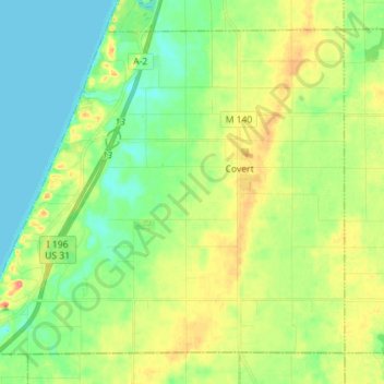
Name: Covert Township topographic map, elevation, terrain.
Location: Covert Township, Van Buren County, Michigan, United States (42.24301 -86.36489 42.33147 -86.22353)
Average elevation: 197 m
Minimum elevation: 175 m
Maximum elevation: 234 m
Make a donation
Gear up for your next adventure:
As an Amazon Associate, this site earns from qualifying purchases at no extra cost to you.
Other topographic maps
Click on a map to view its topography, its elevation and its terrain.
Christie Lake
United States > Michigan > Van Buren County > Lawrence Township
Average elevation: 238 m
Maple Grove Corners
United States > Michigan > Van Buren County > South Haven Charter Township
Average elevation: 197 m
Make a donation
Gear up for your next adventure:
As an Amazon Associate, this site earns from qualifying purchases at no extra cost to you.