Geolocate

Leicester topographic map

Click on the map to display elevation.

About this map
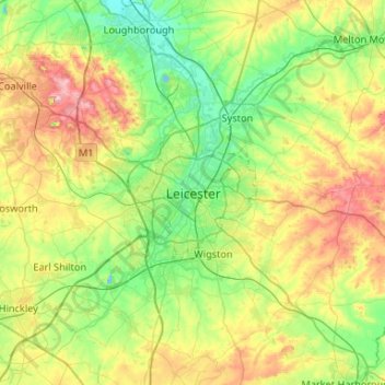
Name: Leicester topographic map, elevation, terrain.

Location: Leicester, City of Leicester, England, LE1 4FB, United Kingdom (52.47620 -1.29320 52.79620 -0.97320)

Average elevation: 109 m

Minimum elevation: 33 m

Maximum elevation: 269 m

Other topographic maps

Click on a map to view its topography, its elevation and its terrain.

River Soar

United Kingdom > England > City of Leicester

Average elevation: 101 m

Gear up for your next adventure:

🎽Hiking Clothing - Breathable clothing for hiking
🔥Camping Stoves - Portable stoves for outdoor cooking
🧥Thermal Emergency Blankets - Compact Mylar blankets to prevent hypothermia if stranded overnight
🔥Windproof Plasma Lighters - USB rechargeable lighters that work in high-altitude winds
🏃Compression Recovery Socks - Reduce leg fatigue after heavy days of elevation gain

As an Amazon Associate, this site earns from qualifying purchases at no extra cost to you.