
Leicester topographic map
Click on the map to display elevation.
About this map
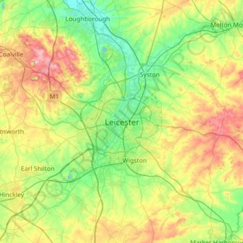
Name: Leicester topographic map, elevation, terrain.
Location: Leicester, Leicestershire, England, LE1 5YA, United Kingdom (52.47620 -1.29320 52.79620 -0.97320)
Average elevation: 109 m
Minimum elevation: 33 m
Maximum elevation: 269 m
Other topographic maps
Click on a map to view its topography, its elevation and its terrain.
Leicestershire
United Kingdom > England > Leicestershire
A large part of the north-west of the county, around Coalville, forms part of the new National Forest area extending into Derbyshire and Staffordshire. The highest point of the county is Bardon Hill at 278 m (912 ft), which is also a Marilyn; with other hilly/upland areas of c. 150–200 metres (490–660 ft)…
Average elevation: 98 m
Ashby-de-la-Zouch
United Kingdom > England > Leicestershire > North West Leicestershire
Average elevation: 132 m