
Harborough topographic map
Click on the map to display elevation.
About this map
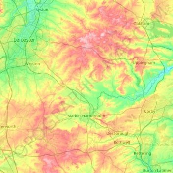
Name: Harborough topographic map, elevation, terrain.
Location: Harborough, Leicestershire, England, United Kingdom (52.39217 -1.30596 52.68496 -0.71330)
Average elevation: 116 m
Minimum elevation: 38 m
Maximum elevation: 234 m
Other topographic maps
Click on a map to view its topography, its elevation and its terrain.
Orton on the Hill
United Kingdom > England > Leicestershire > Hinckley and Bosworth
Average elevation: 86 m