Geolocate

Orakei topographic map

Click on the map to display elevation.

👉 Easily get elevation data in JSON, GeoTIFF and KML formats using Elevation API
Thank you for supporting this site ❤️
Make a donation

Gear up for your next adventure:

As an Amazon Associate, this site earns from qualifying purchases at no extra cost to you.

About this map

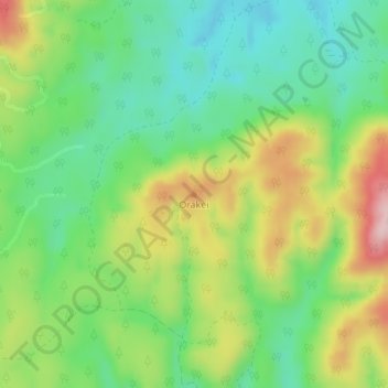
Name: Orakei topographic map, elevation, terrain.

Location: Orakei, Whakatāne District, Bay of Plenty, New Zealand (-38.58636 176.70073 -38.58626 176.70083)

Average elevation: 455 m

Minimum elevation: 360 m

Maximum elevation: 609 m

Gear up for your next adventure:

🧣Merino Neck Gaiters - Versatile headwear for warmth, sun protection, or dust filtering
🧼Biodegradable Outdoor Soap - Clean gear and yourself without harming the local ecosystem
🆘Personal Locator Beacons (PLB) - Satellite emergency beacons for life-saving help in areas with no mobile coverage
🧥Insulated Down Jackets - High warmth-to-weight ratio for cold nights in the high country
🏃Compression Recovery Socks - Reduce leg fatigue after heavy days of elevation gain

As an Amazon Associate, this site earns from qualifying purchases at no extra cost to you.