
Manteigas topographic map
Interactive map
Click on the map to display elevation.
About this map
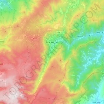
Name: Manteigas topographic map, elevation, terrain.
Location: Manteigas, Guarda, Portugal (40.31127 -7.61292 40.46156 -7.41885)
Average elevation: 1,183 m
Minimum elevation: 499 m
Maximum elevation: 1,993 m
The municipality is located in Guarda District; in Centro Region and Beira Interior Norte Subregion. It is located in the Serra da Estrela Mountains, the highest elevation in mainland Portugal. Cities nearby: Guarda, Seia, Gouveia and Covilhã.
Other topographic maps
Click on a map to view its topography, its elevation and its terrain.