
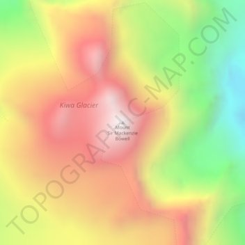
Mount Sir Mackenzie Bowell topographic map
Interactive map
Click on the map to display elevation.
About this map
Name: Mount Sir Mackenzie Bowell topographic map, elevation, terrain.
Average elevation: 2,689 m
Minimum elevation: 1,994 m
Maximum elevation: 3,277 m
Other topographic maps
Click on a map to view its topography, its elevation and its terrain.
Tête Jaune Cache
Canada > British Columbia > Regional District of Fraser-Fort George > Area H (Robson Valley/Canoe)
Tête Jaune Cache, Area H (Robson Valley/Canoe), Regional District of Fraser-Fort George, British Columbia, Canada
Average elevation: 789 m
Mount Robson
Canada > British Columbia > Regional District of Fraser-Fort George > Area H (Robson Valley/Canoe)
Mount Robson, Area H (Robson Valley/Canoe), Regional District of Fraser-Fort George, British Columbia, Canada
Average elevation: 3,042 m
Goat River
Canada > British Columbia > Regional District of Fraser-Fort George > Area H (Robson Valley/Canoe)
Goat River, Area H (Robson Valley/Canoe), Regional District of Fraser-Fort George, British Columbia, Canada
Average elevation: 705 m
Eddy
Canada > British Columbia > Regional District of Fraser-Fort George > Area H (Robson Valley/Canoe)
Eddy, Area H (Robson Valley/Canoe), Regional District of Fraser-Fort George, British Columbia, Canada
Average elevation: 729 m
Urling
Canada > British Columbia > Regional District of Fraser-Fort George > Area H (Robson Valley/Canoe)
Urling, Area H (Robson Valley/Canoe), Regional District of Fraser-Fort George, British Columbia, Canada
Average elevation: 696 m
Crescent Spur
Canada > British Columbia > Regional District of Fraser-Fort George > Area H (Robson Valley/Canoe)
Crescent Spur, Area H (Robson Valley/Canoe), Regional District of Fraser-Fort George, British Columbia, Canada
Average elevation: 703 m