
Bisbee topographic map
Click on the map to display elevation.
About this map
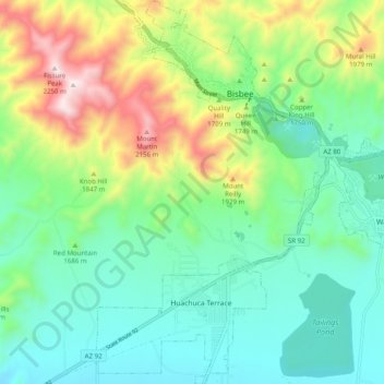
Name: Bisbee topographic map, elevation, terrain.
Location: Bisbee, Cochise County, Arizona, United States (31.37749 -109.95331 31.46222 -109.86746)
Average elevation: 1,661 m
Minimum elevation: 1,451 m
Maximum elevation: 2,238 m
Other topographic maps
Click on a map to view its topography, its elevation and its terrain.
Willcox
United States > Arizona > Cochise County
Willcox's high elevation gives it a milder climate than the nearby Valley of the Sun and Sonoran Desert. It also receives more rainfall than Tucson and Phoenix due to the summer monsoon rains and thus it has a hot semi-arid climate (Koppen: BSh)
Average elevation: 1,274 m
Sierra Vista Estates
United States > Arizona > Cochise County > Sierra Vista
Average elevation: 1,429 m
Willcox
United States > Arizona > Cochise County
Willcox's high elevation gives it a milder climate than the nearby Valley of the Sun and Sonoran Desert. It also receives more rainfall than Tucson and Phoenix due to the summer monsoon rains and thus it has a hot semi-arid climate (Koppen: BSh).
Average elevation: 1,274 m
Bakerville
United States > Arizona > Cochise County > Bisbee > Warren
Bakerville is a populated place situated within the city of Bisbee in Cochise County, Arizona, United States. It has an estimated elevation of 5,039 feet (1,536 m) above sea level.
Average elevation: 1,579 m