
Conthey topographic map
Interactive map
Click on the map to display elevation.
About this map
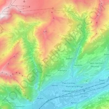
Name: Conthey topographic map, elevation, terrain.
Location: Conthey, Gundis, Wallis, 1964, Schweiz (46.20412 7.15116 46.31640 7.33059)
Average elevation: 1,451 m
Minimum elevation: 473 m
Maximum elevation: 3,194 m
Die Gemeinde erstreckt sich vom Tsanfleurongletscher an der Grenze zum Kanton Waadt bis hinunter an das Ufer der Rhone, von über 3000 m ü. M. bis 460 m ü. M. Sie besteht aus den zehn Ortschaften Aven, Châteauneuf, Conthey, Daillon, Erde, Le Bourg, Premploz, Sensine, St-Séverin und Vens zusammen, wobei sich die grössten – Plan-Conthey und Châteauneuf – in der Rhône-Ebene befinden, kleinere wie Sensine, Erde, Premploz oder Daillon auf verschiedenen Höhenstufen bis auf 930 m ü. M.
Other topographic maps
Click on a map to view its topography, its elevation and its terrain.