Geolocate

Inverie topographic map

Click on the map to display elevation.

About this map

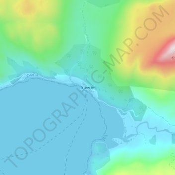
Name: Inverie topographic map, elevation, terrain.

Location: Inverie, Highland, Scotland, PH41 4PL, United Kingdom (57.01859 -5.70518 57.05859 -5.66518)

Average elevation: 147 m

Minimum elevation: 0 m

Maximum elevation: 765 m

Other topographic maps

Click on a map to view its topography, its elevation and its terrain.

Strathnairn

United Kingdom > Scotland > Highland > Daviot

Average elevation: 268 m

Loch Ness

United Kingdom > Scotland > Highland > Dores

Average elevation: 340 m

Whitebridge

United Kingdom > Scotland > Highland

Average elevation: 223 m

Glen Coe

United Kingdom > Scotland > Highland > Glencoe

Average elevation: 414 m

Gear up for your next adventure:

🧰Survival Kits - Essential survival gear
👖Convertible Hiking Trousers - Zip-off legs to adapt to changing temperatures throughout the day
🏕️Camping Gear - Essential camping equipment
🔦Powerful LED Headlamps - Hands-free lighting for night navigation and setting up camp after dark
🛠️Outdoor Repair Kits - Gear repair kits

As an Amazon Associate, this site earns from qualifying purchases at no extra cost to you.