
Aysén Region topographic map
Interactive map
Click on the map to display elevation.
Aysén Region
Corresponding to the Northern Patagonian Ice Field and the Southern Patagonian Ice Field, which are located at higher altitudes, temperatures are cold enough to maintain permanent ice fields. These two ice fields receive abundant precipitation year-round, particularly in the west facing slopes of the Andes that descend to the ocean and fiords. The climate is very windy. No meteorological stations exist in the ice fields so it is estimated that the average high, average low and mean temperatures are below 0 °C (32.0 °F) in all months to maintain permanent ice fields.
About this map
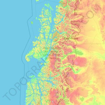
Name: Aysén Region topographic map, elevation, terrain.
Location: Aysén Region, Chile (-49.21153 -75.70038 -43.58599 -71.09116)
Average elevation: 438 m
Minimum elevation: -2 m
Maximum elevation: 3,839 m
Other topographic maps
Click on a map to view its topography, its elevation and its terrain.
Puerto Williams
Chile > Magallanes and Chilean Antarctica Region > Provincia de la Antártica Chilena > Cape Horn
The climate of Puerto Williams is a tundra climate (ET) bordering closely on a subpolar oceanic climate (Cfc) according to the Köppen climate classification. The summers are short and cool while the winters are long, wet, but moderate. Rainfall is around 512.3 mm (20 in) a year and temperatures are steady…
Average elevation: 151 m
Villa Alegre
Chile > Santiago Metropolitan Region > Provincia de Melipilla > Melipilla
Average elevation: 144 m
Mineral El Salvador
Chile > Atacama Region > Provincia de Chañaral > Diego de Almagro
Average elevation: 2,772 m
Comunidad Juan Neculqueo
Chile > Araucanía Region > Provincia de Cautín > Temuco
Average elevation: 110 m
Lo Solar
Chile > Santiago Metropolitan Region > Provincia de Chacabuco > Estación Colina
Average elevation: 498 m
Zona Austral
Chile > Region of Magallanes and Chilean Antarctica > Provincia de Última Esperanza > Puerto Natales
In the far south (Chile Austral), which extends from Valdivia through the Chacao Channel to Cape Horn, the Andes and the South Pacific meet. This district of the country is mountainous, heavily forested and inhospitable. The deeply indented coastline is filled with islands which preserve the general outline of…
Average elevation: 768 m
Norte Grande
Chile > Antofagasta Region > Provincia de Antofagasta > Sierra Gorda
The desert region is an elevated arid plateau descending gradually from the Andes towards the coast, where it breaks down abruptly from elevations of 800 to 1500 ft. From the sea this plateau escarpment has the appearance of a range of flat topped hills closely following the coast line. This topography…
Average elevation: 2,112 m
Villa Cerro Castillo
Chile > Aysén Region > Provincia de General Carrera > Río Ibáñez
Average elevation: 379 m
Volcán Villarrica
Chile > Araucanía Region > Provincia de Cautín > Villarrica
Average elevation: 2,316 m
Punta Pite
Chile > Valparaiso Region > Provincia de Petorca > Zapallar > Punta Pite Norte
Average elevation: 35 m
Santiago
Chile > Santiago Metropolitan Region > Provincia de Santiago > Santiago
The city lies in the center of the Santiago Basin, a large bowl-shaped valley consisting of broad and fertile lands surrounded by mountains. The city has a varying elevation, gradually increasing from 400 m (1,312 ft) in the western areas to more than 700 m (2,297 ft) in the eastern areas. Santiago's…
Average elevation: 724 m
Cape Horn
Chile > Region of Magallanes and Chilean Antarctica > Provincia de la Antártica Chilena > Cape Horn
Average elevation: 49 m
Viña del Mar
Chile > Valparaiso Region > Provincia de Valparaíso > Viña del Mar
Average elevation: 152 m
Puerto Natales
Chile > XII Region of Magallanes and Chilean Antarctica > Puerto Natales
Average elevation: 141 m
Atacama Desert
Chile > Antofagasta Region > Antofagasta
The Coastal Cliff of northern Chile west of the Chilean Coast Range is the main topographical feature of the coast. The geomorphology of the Atacama Desert has been characterized as a low-relief bench "similar to a giant uplifted terrace" by Armijo and co-workers. The intermediate depression (or Central…
Average elevation: 1,961 m
Guallatiri
Chile > Arica and Parinacota Region > Putre
Guallatiri has been active in historical times with a number of eruptions, the latest in 1960. Fumarolic and seismic activity is ongoing and has resulted in the deposition of sulfur and other minerals on the volcano. The volcano is covered by an ice cap above 5,500 metres (18,000 ft) elevation. Guallatiri,…
Average elevation: 5,651 m
Chair
Chile > Region of Magallanes and Chilean Antarctica > Provincia de la Antártica Chilena > Cape Horn
Average elevation: 18 m