
Make a donation
Gear up for your next adventure:
As an Amazon Associate, this site earns from qualifying purchases at no extra cost to you.
Santiago topographic map
Click on the map to display elevation.
Make a donation
Gear up for your next adventure:
As an Amazon Associate, this site earns from qualifying purchases at no extra cost to you.
Santiago
The city lies in the center of the Santiago Basin, a large bowl-shaped valley consisting of broad and fertile lands surrounded by mountains. The city has a varying elevation, gradually increasing from 400 m (1,312 ft) in the western areas to more than 700 m (2,297 ft) in the eastern areas. Santiago's international airport, in the west, lies at an altitude of 474 m (1,555 ft). Plaza Baquedano, near the center, lies at 570 m (1,870 ft). Estadio San Carlos de Apoquindo, at the eastern edge of the city, has an elevation of 960 m (3,150 ft).
Make a donation
Gear up for your next adventure:
As an Amazon Associate, this site earns from qualifying purchases at no extra cost to you.
About this map
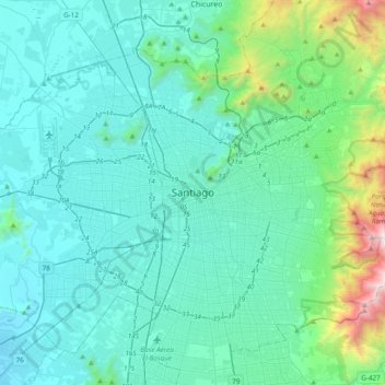
Name: Santiago topographic map, elevation, terrain.
Average elevation: 724 m
Minimum elevation: 415 m
Maximum elevation: 2,754 m
Make a donation
Gear up for your next adventure:
As an Amazon Associate, this site earns from qualifying purchases at no extra cost to you.
Other topographic maps
Click on a map to view its topography, its elevation and its terrain.
Recoleta
Chile > Santiago Metropolitan Region > Provincia de Santiago > Santiago
Average elevation: 556 m
Make a donation
Gear up for your next adventure:
As an Amazon Associate, this site earns from qualifying purchases at no extra cost to you.
La Reina
Chile > Santiago Metropolitan Region > Provincia de Santiago > Santiago
Average elevation: 773 m
Make a donation
Gear up for your next adventure:
As an Amazon Associate, this site earns from qualifying purchases at no extra cost to you.
Santiago
Chile > Santiago Metropolitan Region > Provincia de Santiago
The city lies in the center of the Santiago Basin, a large bowl-shaped valley consisting of broad and fertile lands surrounded by mountains. The city has a varying elevation, gradually increasing from 400 m (1,312 ft) in the western areas to more than 700 m (2,297 ft) in the eastern areas. Santiago's…
Average elevation: 553 m
Make a donation
Gear up for your next adventure:
As an Amazon Associate, this site earns from qualifying purchases at no extra cost to you.
Lo Barnechea
Chile > Santiago Metropolitan Region > Provincia de Santiago
Its pre-Hispanic inhabitants were called huaicoches (in Mapudungún: waykoche 'people who live in a landslide zone') because of the huaicos or huaycos of the region (in Quechua: wayqu 'stream'). Also called lloclla (in Quechua: lluqlla 'alluvium'), these are violent alluvial floods in which a large amount of…
Average elevation: 2,383 m
Santiago
Chile > Santiago Metropolitan Region > Provincia de Santiago
The city lies in the center of the Santiago Basin, a large bowl-shaped valley consisting of broad and fertile lands surrounded by mountains. The city has a varying elevation, gradually increasing from 400 m (1,312 ft) in the western areas to more than 700 m (2,297 ft) in the eastern areas. Santiago's…
Average elevation: 553 m
Make a donation
Gear up for your next adventure:
As an Amazon Associate, this site earns from qualifying purchases at no extra cost to you.
Parque Quinta Normal
Chile > Santiago Metropolitan Region > Provincia de Santiago > Santiago
Average elevation: 526 m
Make a donation
Gear up for your next adventure:
As an Amazon Associate, this site earns from qualifying purchases at no extra cost to you.
La Pintana
Chile > Santiago Metropolitan Region > Provincia de Santiago > La Pintana
Average elevation: 625 m
Conchalí
Chile > Santiago Metropolitan Region > Provincia de Santiago > Conchalí
Average elevation: 510 m
Pedro Aguirre Cerda
Chile > Santiago Metropolitan Region > Provincia de Santiago
Average elevation: 529 m
Peñalolén
Chile > Santiago Metropolitan Region > Provincia de Santiago > Santiago
Average elevation: 965 m
Make a donation
Gear up for your next adventure:
As an Amazon Associate, this site earns from qualifying purchases at no extra cost to you.