Geolocate

溪口镇 topographic map

Interactive map

Click on the map to display elevation.

About this map

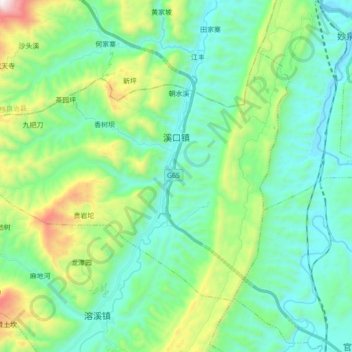
Name: 溪口镇 topographic map, elevation, terrain.

Location: 溪口镇, 秀山土家族苗族自治县, 重庆市, 中国 (28.52873 108.79891 28.63720 108.97431)

Average elevation: 585 m

Minimum elevation: 286 m

Maximum elevation: 1,567 m

Other topographic maps

Click on a map to view its topography, its elevation and its terrain.

坝麻村

中国 > 重庆市 > 秀山土家族苗族自治县 > 龙凤坝镇

坝麻村, 龙凤坝镇, 秀山土家族苗族自治县, 重庆市, 中国

Average elevation: 724 m

膏田镇

中国 > 重庆市 > 秀山土家族苗族自治县

膏田镇, 秀山土家族苗族自治县, 重庆市, 中国

Average elevation: 684 m

大溪乡

中国 > 重庆市 > 秀山土家族苗族自治县

大溪乡, 秀山土家族苗族自治县, 渝东南武陵山区城镇群, 重庆市, 中国

Average elevation: 464 m

岑溪乡

中国 > 重庆市 > 秀山土家族苗族自治县

岑溪乡, 秀山土家族苗族自治县, 重庆市, 中国

Average elevation: 565 m

秀山县

中国 > 重庆市 > 秀山土家族苗族自治县 > 中和街道

秀山县, 中和街道, 秀山土家族苗族自治县, 重庆市, 中国

Average elevation: 582 m

里仁镇

中国 > 重庆市 > 秀山土家族苗族自治县 > 里仁镇

里仁镇, 秀山土家族苗族自治县, 渝东南武陵山区城镇群区位, 重庆市, 中国

Average elevation: 604 m