
Municipio Atocha topographic map
Interactive map
Click on the map to display elevation.
About this map
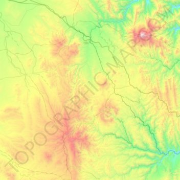
Name: Municipio Atocha topographic map, elevation, terrain.
Location: Municipio Atocha, Sur Chichas, Potosí, Bolivia (-21.33092 -66.49136 -20.87145 -65.85334)
Average elevation: 4,039 m
Minimum elevation: 3,260 m
Maximum elevation: 5,491 m
Other topographic maps
Click on a map to view its topography, its elevation and its terrain.
Atocha
Bolivia > Potosí > Sur Chichas > Municipio Atocha > Atocha
Atocha, Municipio Atocha, Sur Chichas, Potosí, Bolivia
Average elevation: 3,736 m