
Make a donation
Gear up for your next adventure:
As an Amazon Associate, this site earns from qualifying purchases at no extra cost to you.
Mount Helena topographic map
Click on the map to display elevation.
Make a donation
Gear up for your next adventure:
As an Amazon Associate, this site earns from qualifying purchases at no extra cost to you.
About this map
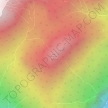
Name: Mount Helena topographic map, elevation, terrain.
Average elevation: 1,061 m
Minimum elevation: 0 m
Maximum elevation: 1,739 m
Make a donation
Gear up for your next adventure:
As an Amazon Associate, this site earns from qualifying purchases at no extra cost to you.
Other topographic maps
Click on a map to view its topography, its elevation and its terrain.
Princess Louisa Marine Provincial Park
Canada > British Columbia > Sunshine Coast Regional District > Area A (Egmont/Pender Harbour)
Average elevation: 737 m
Sakinaw Lake
Canada > British Columbia > Sunshine Coast Regional District > Area A (Egmont/Pender Harbour)
Average elevation: 115 m
Nelson Island
Canada > British Columbia > Sunshine Coast Regional District > Area A (Egmont/Pender Harbour)
Average elevation: 88 m
Kelly Island
Canada > British Columbia > Sunshine Coast Regional District > Area A (Egmont/Pender Harbour)
Average elevation: 14 m
Make a donation
Gear up for your next adventure:
As an Amazon Associate, this site earns from qualifying purchases at no extra cost to you.
Ruby Lake
Canada > British Columbia > Sunshine Coast Regional District > Area A (Egmont/Pender Harbour)
Average elevation: 105 m
Nelson Island
Canada > British Columbia > Sunshine Coast Regional District > Area A (Egmont/Pender Harbour)
Average elevation: 88 m
Macdonald Island
Canada > British Columbia > Sunshine Coast Regional District > Area A (Egmont/Pender Harbour)
Average elevation: 230 m