
Gela topographic map
Interactive map
Click on the map to display elevation.
About this map
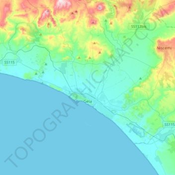
Name: Gela topographic map, elevation, terrain.
Location: Gela, Caltanissetta, Sizilien, 93012, Italien (37.00208 14.11497 37.17205 14.44410)
Average elevation: 84 m
Minimum elevation: 0 m
Maximum elevation: 530 m
Das Kastell Castelluccio aus dem 14. Jahrhundert liegt weithin sichtbar auf einer Anhöhe 7 km nördlich von Gela.
Other topographic maps
Click on a map to view its topography, its elevation and its terrain.
Caltanissetta
Italien > Sizilien > Caltanissetta
Caltanissetta, Sizilien, 93100, Italien
Average elevation: 428 m