
Lluchmayor topographic map
Interactive map
Click on the map to display elevation.
About this map
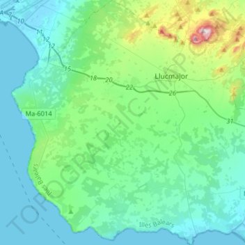
Name: Lluchmayor topographic map, elevation, terrain.
Location: Lluchmayor, Migjorn, Islas Baleares, España (39.35228 2.72187 39.55191 2.97645)
Average elevation: 89 m
Minimum elevation: -2 m
Maximum elevation: 541 m
Other topographic maps
Click on a map to view its topography, its elevation and its terrain.
Cala Figuera
España > Islas Baleares > Migjorn > Santañí
Cala Figuera, Santañí, Migjorn, Islas Baleares, 07659, España
Average elevation: 14 m