
Make a donation
Gear up for your next adventure:
As an Amazon Associate, this site earns from qualifying purchases at no extra cost to you.
Dachau topographic map
Click on the map to display elevation.
Make a donation
Gear up for your next adventure:
As an Amazon Associate, this site earns from qualifying purchases at no extra cost to you.
Dachau
Dachau (German pronunciation: [ˈdaxaʊ] ) is a town in the Upper Bavaria district of Bavaria, a state in the southern part of Germany. It is a major district town—a Große Kreisstadt—of the administrative region of Upper Bavaria, about 20 kilometres (12 miles) north-west of Munich. It is now a popular residential area for people working in Munich, with roughly 45,000 inhabitants. The historic centre of town with its 18th-century castle is situated on an elevation and visible over a great distance.
Make a donation
Gear up for your next adventure:
As an Amazon Associate, this site earns from qualifying purchases at no extra cost to you.
About this map
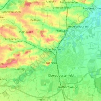
Name: Dachau topographic map, elevation, terrain.
Location: Dachau, Landkreis Dachau, Bavaria, 85221, Germany (48.22750 11.38439 48.31171 11.50253)
Average elevation: 490 m
Minimum elevation: 462 m
Maximum elevation: 538 m
Make a donation
Gear up for your next adventure:
As an Amazon Associate, this site earns from qualifying purchases at no extra cost to you.
Other topographic maps
Click on a map to view its topography, its elevation and its terrain.