
Hohe Tatra topographic map
Interactive map
Click on the map to display elevation.
About this map
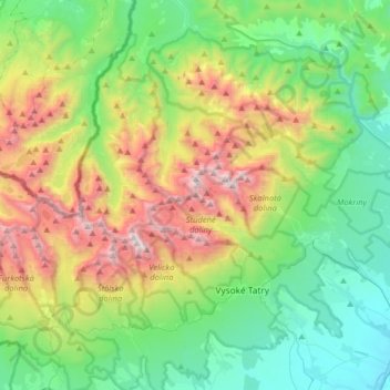
Name: Hohe Tatra topographic map, elevation, terrain.
Average elevation: 1,268 m
Minimum elevation: 647 m
Maximum elevation: 2,611 m
Other topographic maps
Click on a map to view its topography, its elevation and its terrain.
Gerlsdorfer Spitze
Slowakei > Eperieser Landschaftsverband > Bezirk Deutschendorf
Gerlsdorfer Spitze, Bezirk Deutschendorf, Eperieser Landschaftsverband, Ostslowakei, Slowakei
Average elevation: 2,102 m
Tschirmer See
Slowakei > Eperieser Landschaftsverband > Bezirk Deutschendorf
Tschirmer See, Pri jazere, Štrba - Štrbské pleso, Tschirm, Bezirk Deutschendorf, Eperieser Landschaftsverband, Ostslowakei, 05985, Slowakei
Average elevation: 1,309 m
Poppersee
Slowakei > Eperieser Landschaftsverband > Bezirk Deutschendorf
Poppersee, red trail, Tschirmer See, Hohe Tatra, Bezirk Deutschendorf, Eperieser Landschaftsverband, Ostslowakei, 05985, Slowakei
Average elevation: 1,739 m