Geolocate

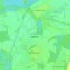
Bad Schönborn topographic map

Click on the map to display elevation.

About this map

Name: Bad Schönborn topographic map, elevation, terrain.

Location: Bad Schönborn, VVG der Gemeinde Bad Schönborn, Landkreis Karlsruhe, Baden-Württemberg, 76669, Germany (49.18947 8.57346 49.24343 8.69149)

Average elevation: 134 m

Minimum elevation: 98 m

Maximum elevation: 245 m

Other topographic maps

Click on a map to view its topography, its elevation and its terrain.
Gear up for your next adventure:

📡Satellite Messengers - Emergency communication devices
🏃Compression Recovery Socks - Reduce leg fatigue after heavy days of elevation gain
🩹First Aid Kits - Emergency kits for hiking
🛌Compact Down Sleeping Bags - Warmth without the bulk, ideal for backcountry camping
🧢Wide Brim Sun Hats - Maximum coverage for the face and neck while out in the open

As an Amazon Associate, this site earns from qualifying purchases at no extra cost to you.