
Make a donation
Gear up for your next adventure:
As an Amazon Associate, this site earns from qualifying purchases at no extra cost to you.
Vanderhoof topographic map
Click on the map to display elevation.
Make a donation
Gear up for your next adventure:
As an Amazon Associate, this site earns from qualifying purchases at no extra cost to you.
About this map
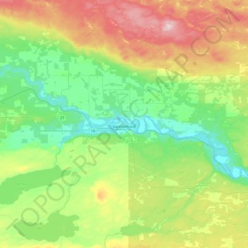
Name: Vanderhoof topographic map, elevation, terrain.
Average elevation: 739 m
Minimum elevation: 627 m
Maximum elevation: 961 m
Make a donation
Gear up for your next adventure:
As an Amazon Associate, this site earns from qualifying purchases at no extra cost to you.
Other topographic maps
Click on a map to view its topography, its elevation and its terrain.
Bulkley Valley
Canada > British Columbia > Regional District of Bulkley-Nechako
Average elevation: 1,050 m
Skeena Mountains
Canada > British Columbia > Regional District of Bulkley-Nechako > Area C (Stuart Lake/Omineca Valley)
Average elevation: 1,339 m
Nechako Plateau
Canada > British Columbia > Regional District of Bulkley-Nechako > Area G (Morice Valley/Babine Valley)
Average elevation: 965 m
Silver Creek
Canada > British Columbia > Regional District of Bulkley-Nechako > Area C (Stuart Lake/Omineca Valley)
Average elevation: 1,005 m
Make a donation
Gear up for your next adventure:
As an Amazon Associate, this site earns from qualifying purchases at no extra cost to you.
Grassy Plains
Canada > British Columbia > Regional District of Bulkley-Nechako > Area E (Ootsa Lake/François Lake)
Average elevation: 911 m
Rose Lake
Canada > British Columbia > Regional District of Bulkley-Nechako > Area B (Broman Lake/Sheraton)
Average elevation: 775 m
Fort Fraser
Canada > British Columbia > Regional District of Bulkley-Nechako > Area D (Endako/Fort Fraser)
Average elevation: 732 m
Mount Germansen
Canada > British Columbia > Regional District of Bulkley-Nechako > Area C (Stuart Lake/Omineca Valley)
Average elevation: 1,701 m
Make a donation
Gear up for your next adventure:
As an Amazon Associate, this site earns from qualifying purchases at no extra cost to you.
Mount Milligan
Canada > British Columbia > Regional District of Bulkley-Nechako > Area C (Stuart Lake/Omineca Valley)
Average elevation: 1,199 m
Donald Lake
Canada > British Columbia > Regional District of Bulkley-Nechako > Area C (Stuart Lake/Omineca Valley)
Average elevation: 808 m
Mount Ogden
Canada > British Columbia > Regional District of Bulkley-Nechako > Area C (Stuart Lake/Omineca Valley)
Average elevation: 1,614 m
Emmett Lake
Canada > British Columbia > Regional District of Bulkley-Nechako > Area D (Endako/Fort Fraser)
Average elevation: 966 m
Make a donation
Gear up for your next adventure:
As an Amazon Associate, this site earns from qualifying purchases at no extra cost to you.
Smaby Peak
Canada > British Columbia > Regional District of Bulkley-Nechako > Area E (Ootsa Lake/François Lake)
Average elevation: 1,740 m
Smith Island
Canada > British Columbia > Regional District of Bulkley-Nechako > Area C (Stuart Lake/Omineca Valley)
Average elevation: 886 m
Fort Fraser
Canada > British Columbia > Regional District of Bulkley-Nechako > Area D (Endako/Fort Fraser)
Average elevation: 732 m
Old Fort
Canada > British Columbia > Regional District of Bulkley-Nechako > Area G (Morice Valley/Babine Valley)
Average elevation: 784 m
Make a donation
Gear up for your next adventure:
As an Amazon Associate, this site earns from qualifying purchases at no extra cost to you.
Omineca Mountains
Canada > British Columbia > Regional District of Bulkley-Nechako > Area C (Stuart Lake/Omineca Valley)
Average elevation: 919 m
Babine Range
Canada > British Columbia > Regional District of Bulkley-Nechako > Area A (Hudson Bay Mountain)
Average elevation: 1,893 m
St. Mary Lake
Canada > British Columbia > Regional District of Bulkley-Nechako > Area C (Stuart Lake/Omineca Valley)
Average elevation: 807 m
Smoke Mountain
Canada > British Columbia > Regional District of Bulkley-Nechako > Area E (Ootsa Lake/François Lake)
Average elevation: 1,475 m
Make a donation
Gear up for your next adventure:
As an Amazon Associate, this site earns from qualifying purchases at no extra cost to you.