Geolocate

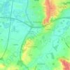
Hurst topographic map

Click on the map to display elevation.

About this map

Name: Hurst topographic map, elevation, terrain.

Location: Hurst, Borough of Wokingham, England, RG10 0DW, United Kingdom (51.43660 -0.87422 51.47660 -0.83422)

Average elevation: 40 m

Minimum elevation: 31 m

Maximum elevation: 63 m

Other topographic maps

Click on a map to view its topography, its elevation and its terrain.

Charvil

United Kingdom > England > Borough of Wokingham

Average elevation: 43 m

Earley

United Kingdom > England > Borough of Wokingham

Average elevation: 53 m

Sonning

United Kingdom > England > Borough of Wokingham

Average elevation: 45 m

Twyford

United Kingdom > England > Borough of Wokingham

Average elevation: 41 m

Woodley

United Kingdom > England > Borough of Wokingham

Average elevation: 50 m

Charvil

United Kingdom > England > Borough of Wokingham

Average elevation: 43 m

Gear up for your next adventure:

🎒Tactical Waist Packs - Quick access to your compass, phone, and snacks while walking
🔌Fast Charging Adapters - Quickly top up all your gear before heading back into the field
🧺Waterproof Dry Sacks - Organize your pack and keep electronics safe from rain and river crossings
🧳Outdoor Travel Organizers - Gear organization accessories
🛰️Handheld GPS Units - Rugged GPS devices for tracking coordinates and elevation in the Australian bush

As an Amazon Associate, this site earns from qualifying purchases at no extra cost to you.