
Starnberg topographic map
Interactive map
Click on the map to display elevation.
About this map
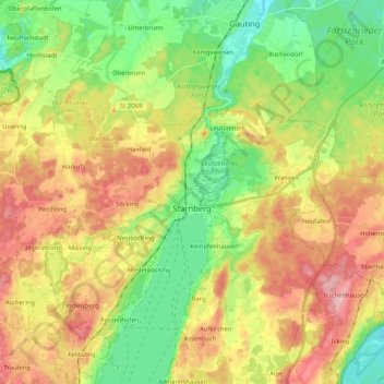
Name: Starnberg topographic map, elevation, terrain.
Location: Starnberg, Landkreis Starnberg, Bavaria, 82319, Germany (47.97293 11.22364 48.03920 11.43350)
Average elevation: 631 m
Minimum elevation: 554 m
Maximum elevation: 729 m
Other topographic maps
Click on a map to view its topography, its elevation and its terrain.
Tutzing
Germany > Bavaria > Landkreis Starnberg
Tutzing, Landkreis Starnberg, Bavaria, 82327, Germany
Average elevation: 632 m
Leoni
Germany > Bavaria > Landkreis Starnberg
Leoni, Berg, Landkreis Starnberg, Bavaria, 82335, Germany
Average elevation: 616 m
Mühlfeld
Germany > Bavaria > Landkreis Starnberg > Herrsching am Ammersee
Mühlfeld, Herrsching am Ammersee, Wörthsee, Landkreis Starnberg, Bavaria, 82237, Germany
Average elevation: 581 m
Söcking
Germany > Bavaria > Landkreis Starnberg > Starnberg
Söcking, Starnberg, Wörthsee, Landkreis Starnberg, Bavaria, 82237, Germany
Average elevation: 651 m
Weßling
Germany > Bavaria > Landkreis Starnberg
Weßling, Landkreis Starnberg, Bavaria, 82234, Germany
Average elevation: 591 m