
Village of Lake Placid topographic map
Interactive map
Click on the map to display elevation.
About this map
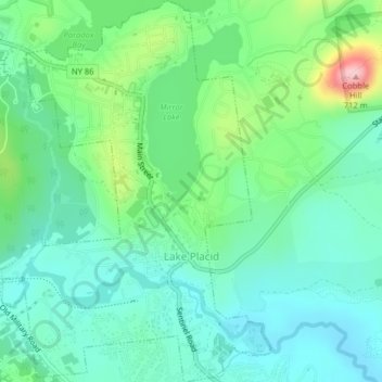
Name: Village of Lake Placid topographic map, elevation, terrain.
Average elevation: 558 m
Minimum elevation: 507 m
Maximum elevation: 701 m
Lake Placid is well known among winter-sports enthusiasts for its skiing, both Alpine and Nordic. Whiteface Mountain (4,867 ft or 1,483 m), in nearby Wilmington about 13 miles (21 km) from Lake Placid, offers skiing, hiking, gondola rides, and mountain biking, and is the only one of the High Peaks that can be reached by an auto road. Whiteface Mountain has a vertical elevation of 3,430 feet (1,050 m), the highest vertical elevation of mountains in Eastern North America. The area has one of only 16 bobsled runs in the Western Hemisphere.
Other topographic maps
Click on a map to view its topography, its elevation and its terrain.
Town of Newcomb
United States > New York > Essex County
Town of Newcomb, Essex County, New York, 12852, United States
Average elevation: 627 m
Brown Mountain
United States > New York > Essex County > Keene
Brown Mountain, Keene, Essex County, New York, 12942, United States
Average elevation: 488 m
Town of Keene
United States > New York > Essex County
Town of Keene, Essex County, New York, United States, Saddleback Mountain
Average elevation: 1,113 m
Mount Lewis
United States > New York > Essex County > Crown Point
Mount Lewis, Crown Point, Essex County, New York, United States
Average elevation: 350 m