
Cambridge topographic map
Click on the map to display elevation.
About this map
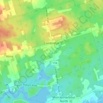
Name: Cambridge topographic map, elevation, terrain.
Location: Cambridge, Kings County, Prince Edward Island, Canada (46.04819 -62.54643 46.09330 -62.49453)
Average elevation: 17 m
Minimum elevation: -5 m
Maximum elevation: 44 m
Other topographic maps
Click on a map to view its topography, its elevation and its terrain.
Prince Edward Island National Park
Canada > Prince Edward Island > Kings County > Greenwich
Average elevation: 2 m