
Lääne-Harju vald topographic map
Interactive map
Click on the map to display elevation.
About this map
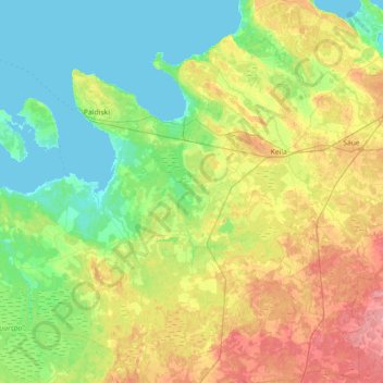
Name: Lääne-Harju vald topographic map, elevation, terrain.
Location: Lääne-Harju vald, Kreis Harrien, Estland (59.12924 23.73002 59.41656 24.44566)
Average elevation: 23 m
Minimum elevation: -1 m
Maximum elevation: 69 m
Other topographic maps
Click on a map to view its topography, its elevation and its terrain.
Tallinn
Tallinn, Stadtgemeinde Reval, Kreis Harrien, Estland
Average elevation: 16 m
Lõunaküla / Storbyn
Lõunaküla / Storbyn, Viimsi vald, Kreis Harrien, 74022, Estland
Average elevation: 12 m