
Elsfleth topographic map
Interactive map
Click on the map to display elevation.
About this map
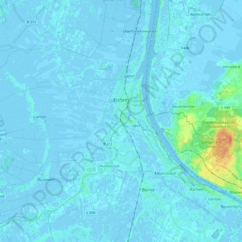
Name: Elsfleth topographic map, elevation, terrain.
Location: Elsfleth, Landkreis Wesermarsch, Nedersaksen, 26931, Duitsland (53.15278 8.29294 53.29386 8.48985)
Average elevation: 2 m
Minimum elevation: -4 m
Maximum elevation: 31 m
Other topographic maps
Click on a map to view its topography, its elevation and its terrain.
Mitteldeich
Duitsland > Nedersaksen > Landkreis Wesermarsch > Butjadingen
Mitteldeich, Butjadingen, Landkreis Wesermarsch, Nedersaksen, 26969, Duitsland
Average elevation: -1 m