Geolocate

Encanto topographic map

Click on the map to display elevation.

About this map

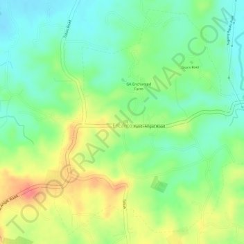
Name: Encanto topographic map, elevation, terrain.

Location: Encanto, Angat, Bulacan, Central Luzon, 3012, Philippines (14.90808 120.99866 14.93301 121.02223)

Average elevation: 58 m

Minimum elevation: 26 m

Maximum elevation: 98 m

Other topographic maps

Click on a map to view its topography, its elevation and its terrain.

Banaban

Philippines > Bulacan > Angat

Average elevation: 55 m

Sulucan

Philippines > Bulacan > Angat

Average elevation: 34 m

Binagbag

Philippines > Bulacan > Angat

Average elevation: 39 m

Paltok

Philippines > Bulacan > Angat

Average elevation: 39 m

Sulucan

Philippines > Bulacan > Angat

Average elevation: 34 m

Sulucan

Philippines > Bulacan > Angat

Average elevation: 34 m

Gear up for your next adventure:

🪑Portable Backpacking Chairs - A comfortable seat for studying maps at the end of the day
🚁Camera Drones with GPS - Capture aerial views of the landscape to compare with topo maps
📍Handheld GPS - GPS devices for hiking and navigation
🌿Flora and Fauna Field Guides - Identify the plants and animals you encounter on your route
🌧️Rain Jackets - Waterproof jackets for hiking

As an Amazon Associate, this site earns from qualifying purchases at no extra cost to you.