
Make a donation
Gear up for your next adventure:
As an Amazon Associate, this site earns from qualifying purchases at no extra cost to you.
Tulalip Shores topographic map
Click on the map to display elevation.
Make a donation
Gear up for your next adventure:
As an Amazon Associate, this site earns from qualifying purchases at no extra cost to you.
About this map
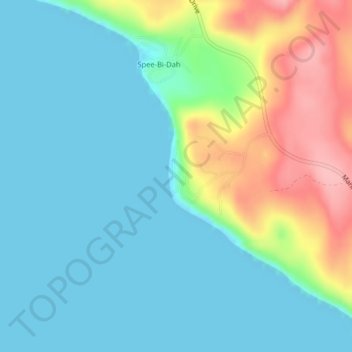
Name: Tulalip Shores topographic map, elevation, terrain.
Average elevation: 34 m
Minimum elevation: 0 m
Maximum elevation: 126 m
Make a donation
Gear up for your next adventure:
As an Amazon Associate, this site earns from qualifying purchases at no extra cost to you.
Other topographic maps
Click on a map to view its topography, its elevation and its terrain.
Walla Walla
United States > Washington > Walla Walla County
Walla Walla County features a varied topography characterized by rolling hills, valleys, and river systems. The elevation in the area averages around 940 feet (approximately 287 meters) above sea level, with some areas rising to nearly 1,200 feet. The landscape is shaped by the Walla Walla River, which carves…
Average elevation: 297 m
Lake Chelan
United States > Washington > Chelan County > Chelan
Lake Chelan (/ʃəˈlæn/ shə-LAN) is a narrow, 50.5 mi (81.3 km) long lake in Chelan County, north-central Washington state, U.S. It is an overdeepened lake and resembles a fjord, with an average width of 1.3 mi (2.1 km). Near its upper end, the lake surface lies more than 6,600 ft (2,000 m) below peaks less…
Average elevation: 1,358 m
Make a donation
Gear up for your next adventure:
As an Amazon Associate, this site earns from qualifying purchases at no extra cost to you.
Make a donation
Gear up for your next adventure:
As an Amazon Associate, this site earns from qualifying purchases at no extra cost to you.
Pacific Beach
United States > Washington > Grays Harbor County > Pacific Beach
Average elevation: 19 m
Make a donation
Gear up for your next adventure:
As an Amazon Associate, this site earns from qualifying purchases at no extra cost to you.
Grand Coulee Dam
United States > Washington > Okanogan County
After power shortages in the Northwest during the 1960s, it was determined the six remaining planned pumps be pump-generators. When energy demand is high, the pump-generators can generate electricity with water from the Banks Lake feeder canal adjacent to the dam at a higher elevation. By 1973, the…
Average elevation: 423 m
Make a donation
Gear up for your next adventure:
As an Amazon Associate, this site earns from qualifying purchases at no extra cost to you.
Mima Mounds Natural Area Preserve
United States > Washington > Thurston County
Average elevation: 62 m
Make a donation
Gear up for your next adventure:
As an Amazon Associate, this site earns from qualifying purchases at no extra cost to you.
Olympic Mountains
The national park is surrounded on the south, east, and northwest sides by the Olympic National Forest, with five wilderness areas, and on the southwest side by the Clearwater State Forest with one Natural Area Preserve (Washington Department of Natural Resources), and the Quinault Indian Reservation. State…
Average elevation: 511 m
Make a donation
Gear up for your next adventure:
As an Amazon Associate, this site earns from qualifying purchases at no extra cost to you.
Make a donation
Gear up for your next adventure:
As an Amazon Associate, this site earns from qualifying purchases at no extra cost to you.
Make a donation
Gear up for your next adventure:
As an Amazon Associate, this site earns from qualifying purchases at no extra cost to you.
Mount Skokomish Wilderness
United States > Washington > Mason County
Mount Skokomish Wilderness is located in the southeast corner of Olympic National Forest, just north of Lake Cushman. It consists of two long rocky ridges running roughly northeast to southwest. Elevations range from about 2,000 feet (609.6 m) to 6,434 feet (1,961.1 m) at the peak of Mount Skokomish on the…
Average elevation: 1,058 m
Make a donation
Gear up for your next adventure:
As an Amazon Associate, this site earns from qualifying purchases at no extra cost to you.
Colfax
United States > Washington > Whitman County
Colfax is located in southeastern Washington at 46°53′3″N 117°21′49″W / 46.88417°N 117.36361°W / 46.88417; -117.36361 (46.884033, -117.363668), at an elevation of 1,962 feet (598 m). The nearest cities are Spokane, Pullman, Moscow, and Lewiston/Clarkston. The area is geologically…
Average elevation: 685 m
Make a donation
Gear up for your next adventure:
As an Amazon Associate, this site earns from qualifying purchases at no extra cost to you.
Ebey's Landing National Historical Reserve
United States > Washington > Island County
Average elevation: 25 m
Make a donation
Gear up for your next adventure:
As an Amazon Associate, this site earns from qualifying purchases at no extra cost to you.
Colchuck Lake
United States > Washington > Chelan County
Colchuck Lake has an area of approximately 87.8 acres (0.355 km2) and a maximum surface elevation of 5,570 feet above sea level, depending on the fluctuation of the depth of the lake. The lake has a tributary basin of 941 acres (3.81 km2) acres, and an average storage capacity estimated at 1,570 acre-feet.
Average elevation: 1,886 m
Make a donation
Gear up for your next adventure:
As an Amazon Associate, this site earns from qualifying purchases at no extra cost to you.
Chopaka Lake
United States > Washington > Okanogan County
Chopaka Lake is a lake in Okanogan County, Washington. It covers an area of approximately 150 acres (0.6 km2), is over 70 ft (21 m) deep at its deepest point, and is 2,910 ft (886 m) in elevation. The lake's name is that of a legendary Okanogan hunter who was transformed to stone by Coyote. It serves as an…
Average elevation: 1,032 m
Make a donation
Gear up for your next adventure:
As an Amazon Associate, this site earns from qualifying purchases at no extra cost to you.
Manitou Beach Park
United States > Washington > Kitsap County > Bainbridge Island
Average elevation: 27 m
Lake Marcel
United States > Washington > King County
Lake Marcel is at an altitude of 295 feet (90 m) above sea level. The lake sits in a bowl at the top of Stillwater Hill on the east side of the Snoqualmie Valley, north of Carnation. It has two main areas of water connected by a channel, and several peninsular features make an extensive shoreline around the…
Average elevation: 110 m
Make a donation
Gear up for your next adventure:
As an Amazon Associate, this site earns from qualifying purchases at no extra cost to you.
Make a donation
Gear up for your next adventure:
As an Amazon Associate, this site earns from qualifying purchases at no extra cost to you.
Make a donation
Gear up for your next adventure:
As an Amazon Associate, this site earns from qualifying purchases at no extra cost to you.
Make a donation
Gear up for your next adventure:
As an Amazon Associate, this site earns from qualifying purchases at no extra cost to you.
Tekoa
United States > Washington > Whitman County
Tekoa was incorporated in 1889 with just under 300 people at the base of Tekoa Mountain (elevation 2,490 feet), on the extreme eastern end of the Palouse, and to the west of the Benewah Range of Idaho. In 1908 the railroad trestle above the town was built. By 1910 the population had grown to 1,694. Over the…
Average elevation: 792 m
Make a donation
Gear up for your next adventure:
As an Amazon Associate, this site earns from qualifying purchases at no extra cost to you.
Bell Hill
United States > Washington > Clallam County > Bell Hill
Bell Hill is located in eastern Clallam County and is bordered to the north by the city of Sequim. The community is named for the hill that it sits on, which rises to an elevation of over 1,000 feet (300 m) above sea level, or more than 800 feet (240 m) above the center of Sequim. Bell Hill actually has two…
Average elevation: 139 m
Make a donation
Gear up for your next adventure:
As an Amazon Associate, this site earns from qualifying purchases at no extra cost to you.
Make a donation
Gear up for your next adventure:
As an Amazon Associate, this site earns from qualifying purchases at no extra cost to you.
Make a donation
Gear up for your next adventure:
As an Amazon Associate, this site earns from qualifying purchases at no extra cost to you.
Make a donation
Gear up for your next adventure:
As an Amazon Associate, this site earns from qualifying purchases at no extra cost to you.
Desert Aire
United States > Washington > Grant County
Desert Aire is a census-designated place (CDP) in Grant County, Washington, United States. Desert Aire's elevation is 560 ft (170 m). The population was 1,626 at the 2010 census, up from 1,124 at the 2000 census.
Average elevation: 177 m
Make a donation
Gear up for your next adventure:
As an Amazon Associate, this site earns from qualifying purchases at no extra cost to you.
Make a donation
Gear up for your next adventure:
As an Amazon Associate, this site earns from qualifying purchases at no extra cost to you.
Chehalis Village
United States > Washington > Grays Harbor County > Chehalis Village
Average elevation: 42 m
Make a donation
Gear up for your next adventure:
As an Amazon Associate, this site earns from qualifying purchases at no extra cost to you.