
Liebenau topographic map
Interactive map
Click on the map to display elevation.
About this map
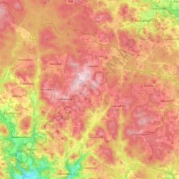
Name: Liebenau topographic map, elevation, terrain.
Location: Liebenau, Bezirk Freistadt, Oberösterreich, 4252, Österreich (48.46368 14.71711 48.56394 14.92163)
Average elevation: 872 m
Minimum elevation: 606 m
Maximum elevation: 1,044 m
Other topographic maps
Click on a map to view its topography, its elevation and its terrain.
Weiße Aist
Österreich > Oberösterreich > Liebenau
Weiße Aist, Liebenau, Freistadt, Oberösterreich, 4252, Österreich
Average elevation: 932 m