
Make a donation
Gear up for your next adventure:
As an Amazon Associate, this site earns from qualifying purchases at no extra cost to you.
Trenčín topographic map
Click on the map to display elevation.
Make a donation
Gear up for your next adventure:
As an Amazon Associate, this site earns from qualifying purchases at no extra cost to you.
Trenčín
Trenčín lies at an altitude of 262 metres (860 ft) above sea level and covers an area of 82 square kilometres (31.7 sq mi). It lies in the Trenčín Basin of north-western Slovakia, which is surrounded by the Strážov Mountains, Považský Inovec and White Carpathians, with the last mentioned being a protected area. The Váh River flows in the north–south axis.
Make a donation
Gear up for your next adventure:
As an Amazon Associate, this site earns from qualifying purchases at no extra cost to you.
About this map
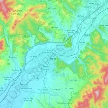
Name: Trenčín topographic map, elevation, terrain.
Average elevation: 307 m
Minimum elevation: 191 m
Maximum elevation: 756 m
Make a donation
Gear up for your next adventure:
As an Amazon Associate, this site earns from qualifying purchases at no extra cost to you.