
Make a donation
Gear up for your next adventure:
As an Amazon Associate, this site earns from qualifying purchases at no extra cost to you.
Buffalo Springs topographic map
Click on the map to display elevation.
Make a donation
Gear up for your next adventure:
As an Amazon Associate, this site earns from qualifying purchases at no extra cost to you.
About this map
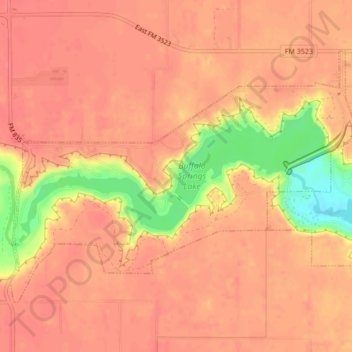
Name: Buffalo Springs topographic map, elevation, terrain.
Location: Buffalo Springs, Lubbock County, Texas, United States (33.52025 -101.72842 33.54562 -101.68580)
Average elevation: 948 m
Minimum elevation: 897 m
Maximum elevation: 962 m
Make a donation
Gear up for your next adventure:
As an Amazon Associate, this site earns from qualifying purchases at no extra cost to you.
Other topographic maps
Click on a map to view its topography, its elevation and its terrain.
Shallowater
United States > Texas > Lubbock County > Shallowater > Shallowater
Average elevation: 1,009 m
Make a donation
Gear up for your next adventure:
As an Amazon Associate, this site earns from qualifying purchases at no extra cost to you.
Buffalo Springs Lake Dam
United States > Texas > Lubbock County > Buffalo Springs
Average elevation: 939 m