Geolocate

Quanzhou topographic map

Click on the map to display elevation.

About this map

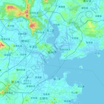
Name: Quanzhou topographic map, elevation, terrain.

Location: Quanzhou, Fengze District, 泉州台商投資區, Quanzhou, Fujian, China (24.71555 118.51236 25.03555 118.83236)

Average elevation: 34 m

Minimum elevation: -3 m

Maximum elevation: 577 m

Other topographic maps

Click on a map to view its topography, its elevation and its terrain.

Quanzhou

China > Fujian

Average elevation: 352 m

Jiulong River

China > Fujian > Yong'an

Average elevation: 402 m

Gear up for your next adventure:

👕UPF 50+ Sun Shirts - Essential protection against the harsh Australian sun during field work
🔥Windproof Plasma Lighters - USB rechargeable lighters that work in high-altitude winds
🛰️Handheld GPS Units - Rugged GPS devices for tracking coordinates and elevation in the Australian bush
👖Convertible Hiking Trousers - Zip-off legs to adapt to changing temperatures throughout the day
🧥Softshell Jackets - Flexible outdoor jackets

As an Amazon Associate, this site earns from qualifying purchases at no extra cost to you.