Geolocate

Quanzhou topographic map

Click on the map to display elevation.

About this map

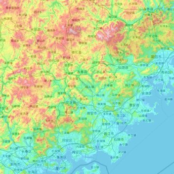
Name: Quanzhou topographic map, elevation, terrain.

Location: Quanzhou, Fujian, China (24.42695 117.55073 25.94330 119.12201)

Average elevation: 352 m

Minimum elevation: -3 m

Maximum elevation: 1,760 m

Other topographic maps

Click on a map to view its topography, its elevation and its terrain.

Anxi

China > Fujian > Anxi County

Average elevation: 300 m

Changqing

China > Fujian > Anxi County

Average elevation: 740 m

Bangshan

China > Fujian > Longhai District

Average elevation: 37 m

Youyang

China > Fujian > Youyang

Average elevation: 543 m

Quanzhou

China > Fujian

Average elevation: 34 m

Jiulong River

China > Fujian > Yong'an

Average elevation: 402 m

Gear up for your next adventure:

🧢Outdoor Sun Hats - Sun protection hats for hiking
🧢Wide Brim Sun Hats - Maximum coverage for the face and neck while out in the open
🧦Hiking Socks - Comfortable socks for long hikes
📱Shockproof Phone Cases - Extra protection for your smartphone against drops on rocky terrain
🔋Rechargeable Batteries - Eco-friendly power for high-drain GPS units and flashlights

As an Amazon Associate, this site earns from qualifying purchases at no extra cost to you.