
Grasleitenhütte topographic map
Interactive map
Click on the map to display elevation.
About this map
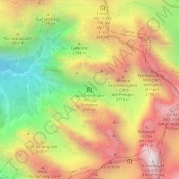
Name: Grasleitenhütte topographic map, elevation, terrain.
Average elevation: 2,375 m
Minimum elevation: 1,703 m
Maximum elevation: 2,986 m
Die Grasleitenhütte befindet sich auf 2165 m Höhe auf dem Gebiet der Gemeinde Tiers. Sie liegt im Grasleitental in der Rosengartengruppe. Volksmündig bezeichnet man die umliegenden grüne Hänge als Grasleiten.
Other topographic maps
Click on a map to view its topography, its elevation and its terrain.
Kesselspitz
Italien > Trentino-Südtirol > Tiers
Kesselspitz, Tiers, Salten-Schlern, Bozen, Trentino-Südtirol, Italien
Average elevation: 1,538 m