
Make a donation
Gear up for your next adventure:
As an Amazon Associate, this site earns from qualifying purchases at no extra cost to you.
Backnang topographic map
Click on the map to display elevation.
Make a donation
Gear up for your next adventure:
As an Amazon Associate, this site earns from qualifying purchases at no extra cost to you.
Backnang
Before 1930 the title for this position was Stadtschultheiß. In 1930 the title became Bürgermeister (Mayor), and in 1956 with the elevation of Backnang to a "large district town," the title was changed to Oberbürgermeister (Lord Mayor).
Make a donation
Gear up for your next adventure:
As an Amazon Associate, this site earns from qualifying purchases at no extra cost to you.
About this map
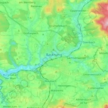
Name: Backnang topographic map, elevation, terrain.
Average elevation: 303 m
Minimum elevation: 216 m
Maximum elevation: 543 m
Make a donation
Gear up for your next adventure:
As an Amazon Associate, this site earns from qualifying purchases at no extra cost to you.
Other topographic maps
Click on a map to view its topography, its elevation and its terrain.