Geolocate

Dundalk topographic map

Click on the map to display elevation.

About this map

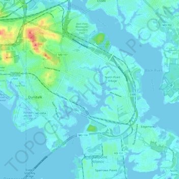
Name: Dundalk topographic map, elevation, terrain.

Location: Dundalk, Baltimore County, Maryland, 21222, United States (39.21475 -76.52985 39.30786 -76.44144)

Average elevation: 6 m

Minimum elevation: -4 m

Maximum elevation: 50 m

Gear up for your next adventure:

🧴Sunscreen SPF - Sun protection for outdoor activities
📱Tablet Tripod Mounts - Steady platforms for viewing digital maps or taking long exposures
Lightweight Tents - Compact tents for backpacking
🥾Heavy Duty Hiking Boots - Ankle-supporting boots for carrying heavy packs on steep contours
📍Handheld GPS - GPS devices for hiking and navigation

As an Amazon Associate, this site earns from qualifying purchases at no extra cost to you.