
Riverwood topographic map
Interactive map
Click on the map to display elevation.
About this map
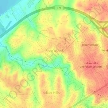
Name: Riverwood topographic map, elevation, terrain.
Location: Riverwood, Jefferson County, Kentucky, United States (38.27686 -85.66730 38.28751 -85.65515)
Average elevation: 162 m
Minimum elevation: 130 m
Maximum elevation: 181 m
Other topographic maps
Click on a map to view its topography, its elevation and its terrain.
Kenwood
United States > Kentucky > Jefferson County > Louisville
Kenwood, Louisville, Jefferson County, Kentucky, 40214, United States
Average elevation: 153 m
Glenview
United States > Kentucky > Jefferson County
Glenview, Jefferson County, Kentucky, 40025, United States
Average elevation: 155 m
Oakdale
United States > Kentucky > Jefferson County > Louisville > Oakdale
Oakdale, Louisville, Jefferson County, Kentucky, 40215, United States
Average elevation: 143 m
Prospect
United States > Kentucky > Jefferson County
Prospect, Jefferson County, Kentucky, United States
Average elevation: 166 m
Coldstream
United States > Kentucky > Jefferson County
Coldstream, Jefferson County, Kentucky, United States
Average elevation: 219 m